On the 9th of February 2023, Malta experienced intense rainfall. Medicane Helios (aka Storm Helios) brought an extraordinary downpour that reached 121 millimetres within a single day, that amounted to over 44.74 billion liters of rainwater over Malta. Streets turned into rivers and communities felt first-hand how vulnerable the islands are to sudden and extreme weather. For many residents the memory is still vivid. For us at AHEAD it became an opportunity to demonstrate how science and technology can provide foresight and preparedness.
At the heart of our response is PHASE 2, the Predictive Hyper Adaptive Simulation Engine. This is not simply a model. It is a full digital twin environment that allows us to recreate and simulate the very dynamics of a storm as it unfolds in urban space. With PHASE 2 we can turn rainfall data into a living simulation that shows where water accumulates, how it moves through streets and what areas are at greatest risk.
Medicanes and Malta’s exposure
Mediterranean tropical like cyclones, often called medicanes, are rare but not unknown in our region. The earliest record we have dates back to St. Paul’s Shipwreck in 59 AD. They form when the right atmospheric and marine conditions come together. For Malta these storms represent an acute risk because they often concentrate rainfall into a short window of time. Unlike broader winter systems a medicane can create extreme flash flooding in hours rather than days.
Storm Helios was one of those events. The rainfall data revealed totals that would overwhelm almost any stormwater drainage system. It is precisely in such conditions that PHASE 2 comes into its own. By transforming meteorological input into a high-resolution digital twin, PHASE 2 empowers decision makers with an operational foresight tool.
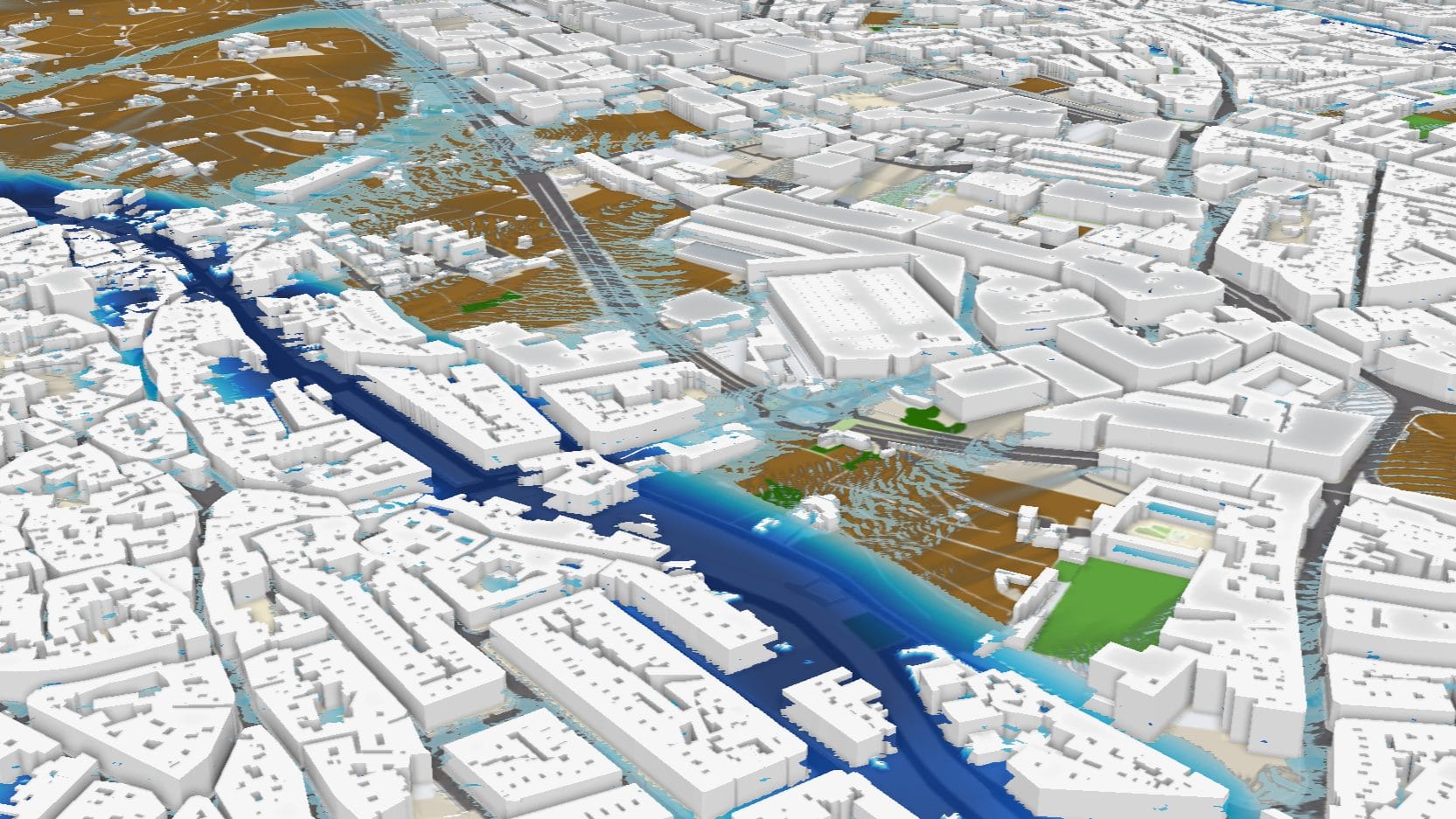
PHASE 2 in operation
The video presented here of the PHASE 2 engine preloaded in the python environment of ESRI’s ArcGIS Pro*, is a direct simulation showing a part of the Maltese locality of Qormi under the rainfall conditions of Helios. Every contour, street and building is integrated into the digital twin. The engine takes the recorded 121 millimetres of rainfall over 24 hours at a resolution of 15 minutes, and translates it into fluid dynamics across the urban landscape.
Watching the simulation is not only a reminder of what occurred but also a demonstration of PHASE 2 in operation. Policymakers can see how critical junctions become inundated. Emergency planners can identify choke points where intervention would be necessary. Local councils can assess which neighbourhoods are most exposed and require protective measures.
PHASE 2 is not a theoretical model left in academic papers. It is a practical instrument that can be run on real data to provide climate foresight anywhere on the globe.
From foresight to intelligence
The power of PHASE 2 lies not only in its ability to reproduce past events but in its capacity to project future ones. When a new storm is approaching, PHASE 2 can take forecast data and run scenarios before the first drop of rain even falls. This is where foresight becomes intelligence.
Climate Intelligence is the systematic use of these simulations to guide adaptation strategies. By continuously feeding data into PHASE 2, Malta for this case study, gains the ability to anticipate, to act early, and to mitigate losses. In the case of Helios, had such a system been in operational use, authorities could have tested different interventions virtually and refined their response before the rainfall peaked.
Towards Climate Command™
PHASE 2 is more than software. It is the backbone of a doctrine we call Climate Command that effectively addresses climate adaptation and resilience. This approach unites simulation, data, and governance into a single operational capability. Climate Command is about moving beyond reacting to disasters and towards directing our preparedness with foresight.
Storm Helios showed the vulnerability of Qormi. PHASE 2 shows the pathway forward. By integrating digital twins into decision making countries can position themselves at the forefront of resilience. Climate Command is not abstract strategy. It is a practical system in which simulations like the one presented here become part of daily planning.
Why Qormi
Choosing Qormi as the simulation zone was deliberate. The locality sits in a natural basin with limited outlets. Flooding there affects not only residents but also major transport routes and businesses. By simulating Qormi during Helios we highlight how PHASE 2 can zoom into critical hotspots and provide precise intelligence.
The simulation output is striking, and the scale of the event becomes clear in three dimensions. This is what makes PHASE 2 unique. It is not a table of numbers. It is an interactive twin of reality that stakeholders can explore, learn from, and act upon.
Lessons from Helios
The rainfall of Helios cannot be dismissed as an anomaly. Climate projections show that extreme precipitation events in the Mediterranean are increasing in frequency and intensity. For Malta, where space is limited and density is high, such events are particularly dangerous.
The lesson is clear. We cannot rely on past averages. We need tools that anticipate extremes. PHASE 2 fulfils that role by translating climate data into operational scenarios. Helios is both a case study and a warning. With PHASE 2 in place we are better prepared for the storms yet to come.
Looking forward
This first public release of a PHASE 2 simulation marks a step forward in how we communicate risk and adaptation. It is not just for researchers but for the public, policymakers, and partners across Europe and beyond. The same engine that recreated Helios in Qormi can be applied to any area of interest.
Our mission at AHEAD is to ensure that this intelligence is accessible and actionable. PHASE 2 is proprietary technology, protected and managed exclusively by AHEAD. It is a Maltese innovation that can be scaled and replicated across small islands and Mediterranean regions.
Storm Helios was one of the most intense rainfall events Malta has ever faced. Through PHASE 2 we transform that memory into foresight. Through Climate Intelligence we give it meaning. Through Climate Command we make it part of a new operational reality.
* PHASE 2 can be deployed as a standalone, or preloaded in QGIS or ArcGIS Pro
Recent Posts
On the 9th of February 2023, Malta experienced intense rainfall. Medicane Helios (aka Storm Helios) brought an extraordinary downpour [...]